The GlobES data cube
The distributions of different ecosystems, from lowland rainforests to alpine wetlands, are a key component of global biodiversity. Accordingly, comprehensive and detailed information on ecosystem distributions in space and their changes through time is urgently needed to support the monitoring framework of the Post-2020 Global Biodiversity Framework, as well as many other vital applications in science, policy, and management.
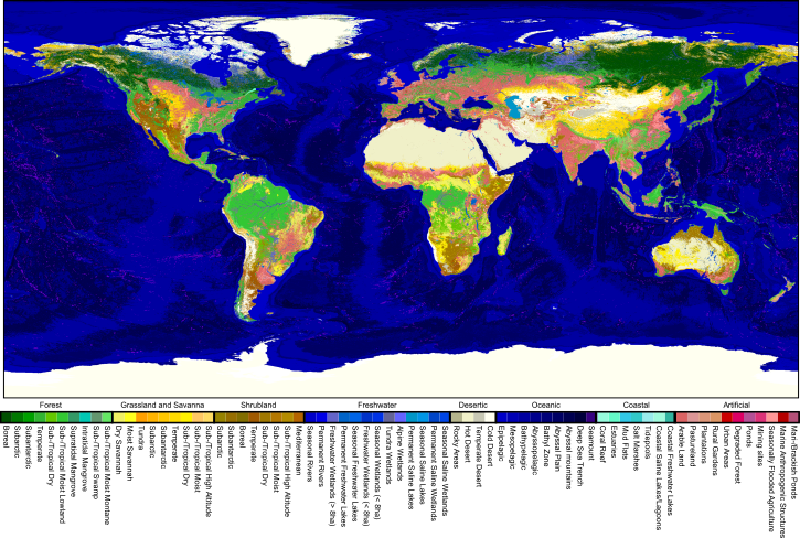
To address this need, we here present a suite of national indicators of ecosystem-specific annual areas and areal changes. These indicators are based on the GlobES (Global EcoSystems) data cube, which maps the per-pixel areas of >70 terrestrial, freshwater, coastal, and oceanic ecosystems annually since 1992 at a high spatial resolution. GlobES builds on recent progress in multi-decadal environmental mapping, integrating state-of-the-art information on land cover and land use, climate, geomorphology, hydrology, and various other environmental factors. For immediate applicability in conservation practice, the ecosystem types correspond to the habitat class scheme of the IUCN Red List of Threatened Species.
Extensive validation of the GlobES data cube against millions of ecosystem and species records has shown high overall accuracies (F1-score of 88%) that, however, vary across different regions and ecosystem types. To allow users to factor that uncertainty into their evaluations of ecosystem status and trends, the presented national ecosystem indicators will soon be associated with uncertainty bars, calculated by aggregating the spatiotemporally detailed uncertainty estimates determined for the GlobES ecosystem maps. As the number of available validation records will continue to increase rapidly, the detail and reliability of the GlobES data and of the associated uncertainties will further improve over the coming years. To allow these improvements to also enhance the precision and reliability of ecosystem monitoring, the national ecosystem indicators and their uncertainty bars will be periodically updated.
The GlobES ecosystem data cube currently undergoes final updates, before the final, fully documented datasets will be published as an open-access resource. To already facilitate discussions and planning, preliminary time series of the GlobES-based national ecosystem indicators are currently made available for exploration and download via this website. However, please note that until the finalization of the GlobES data is announced here, the provided indicator information should be considered preliminary and is not yet fit-for-purpose for official applications in science or policy.
Reference: Ruben Remelgado, Leonie Röhler, and Carsten Meyer. “Global Annual Distribution Data for Terrestrial, Freshwater, Coastal, and Oceanic Ecosystems” (in major revision)


Contact:
Dr. Carsten Meyer, head of research group Macroecology and Society
Email: carsten.meyer@idiv.de
Postal address:
German Centre for Integrative Biodiversity Research (iDiv) Halle-Jena-Leipzig
Puschstrasse 4
04103 Leipzig
Germany
a research group within the German Centre for Integrative Biodiversity Research (iDiv) Halle-Jena-Leipzig
Change (%) in extent of
between years
and 2018